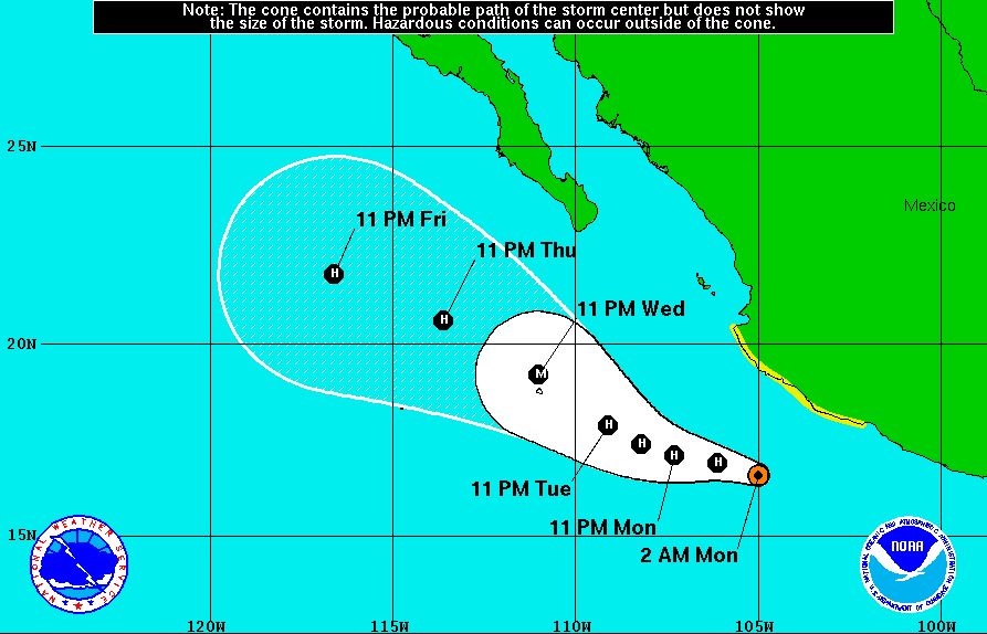
Although not forecast to come too close to Los Cabos, Tropical Storm Dolores is still one to watch for the Baja in terms of possible rainfall and high seas. It is forecast to become a hurricane later today and, as ever with hurricanes, the track can change rapidly and it may become more threatening as the week progresses. Here is the latest from the NOAA:
At 0400 AM CDT (0900 UTC), the center of Tropical Storm
Dolores was located near latitude 16.6 North, longitude 105.0 West. Dolores is moving
toward the west-northwest near 13 mph (20 km/h), and this motion with a
decrease in forward speed is expected through Tuesday.
On the forecast track, Dolores will gradually move away from
the southwestern coast of Mexico today.
Maximum sustained winds are near 65 mph (100 km/h) with
higher gusts. Strengthening is forecast
during the next 48 hours, and Dolores is expected to become a hurricane later
today.
Tropical-storm-force winds extend outward up to 140 miles
(220 km) from the center.
The estimated minimum central pressure is 997 mb (29.44
inches).
Tropical storm conditions are possible within the watch area
this morning.
The outer rain bands of Dolores are expected to produce total
rain accumulations of 2 to 4 inches along the southwestern coast of Mexico from
the state of Oaxaca to Nayarit, and eventually over the southern tip of Baja
California Sur. Isolated maximum amounts of 7 inches are possible.
Swells generated by Dolores are expected to affect the southern
and southwestern coasts of Mexico and the Baja California peninsula during the
next few days, and could cause life-threatening surf and rip current conditions. Please consult products from your local
weather office.